The state, the drought and El Niño: It’s complicated
Just last year, researchers were saying there was no end in sight for California’s drought. But things are looking up, with the arrival of El Niño. Berkeley professor and geologist B. Lynn Ingram discusses what the climate could have in store for us.
January 14, 2016
Just last year, researchers were saying there was no end in sight for California’s recent drought. During the past four years — the driest the state has been in a half-century— reservoirs and lake levels plummeted, leaves on giant trees grew brittle, plants shriveled and groundwater was depleted through excessive pumping for agricultural use.

(UC Berkeley photo by Kevin Ho Nguyen)
But things are looking up. El Niño has swept into the Golden State and is breathing life back into the area. To many, it might seem that this storm front could end the drought and set California back on track. And it is making a difference, but like all things climate-related, it’s complicated and hard to predict.
Berkeley News spoke with Berkeley professor B. Lynn Ingram, a geologist specializing in paleoclimatology, who studies past climate history by examining natural archives — trees, sediments, shells, microfossils — and takes a long-term perspective to predict what the climate could have in store for us.
Is this the most rain the state has seen since the drought began four years ago?

B. Lynn Ingram (left) and Frances Malamud-Roam are co-authors of The West Without Water: What Past Floods, Droughts and Other Climatic Clues Tell Us About Tomorrow. (Photo courtesy of UC Press)
B. Lynn Ingram: Yes — some regions have gotten more rain this water year (which began Oct. 1) than they did for the entire water year of 2014-15. Lower than average precipitation in December, followed by much higher precipitation in January to March or April, is a common pattern with strong El Niños. In 1982-83 and 1997-98 [the other two wettest years in recent history], December had lower than average precipitation, but then starting in January, rainfall was much higher than average and continued for months. We’re seeing the same pattern this year. Based on the 1997-98 event, we can expect to see precipitation levels around 170 percent of normal for the state. In northern California, it has already rained 20 inches, compared to an average of about 39 inches each year for the past four years.
Will this season’s El Niño end the drought?
No. We’re in a water deficit of at least two years in most of California. This means we would need more than a year of precipitation like this. We’d probably need more like two years to restore it.
How likely is this to happen?
It’s not likely we’ll come out of this drought. With climate change, California and the Southwest are predicted to get drier overall with warmer weather and, subsequently, more evaporation. Even with a wetter season this year, even next year, the climate is very likely to continue to be drier. Some are predicting another La Niña next year, which could offset the positive effects of this year’s El Niño.
How do meteorologists determine when we’re out of a drought?

Shasta Lake, a reservoir in Shasta County, had dropped to lower than 20 percent capacity by May 2015. But reservoirs are filling back up with this year’s El Niño. (Flickr photo by torroid)
Being out of a drought means restoring water levels in all the places that water is stored — natural lakes, reservoirs and the ground — to the long-term average. The groundwater is another story because it’s been pumped so much. There’s no way we’re going to replenish that in two years.
Although the drought won’t end this season, what are some of the positive impacts of El Niño?
The rain itself is already filling the reservoirs. Statewide, the reservoirs had dropped to 45 percent of the historical average. It’s hard to predict how much they’ll fill up by the end of the season because it depends how much it rains and how much runoff goes into the reservoirs — in a drought, the rain doesn’t produce as much runoff because it’s first permeating into the dry ground. By the end of this season, reservoirs could be halfway there, maybe up to 70 percent.
The snowpack is already above average statewide, at about 105 percent, so going into spring and summer, the snow will melt and continue to fill up the reservoirs, so that’ll carry over into the summer and fall.

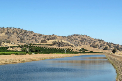
Groundwater in the Central Valley has become extremely depleted from pumping for agricultural use. (Flickr photo by Don Barrett)
El Niño will also help replenish some groundwater, even though levels won’t go back to normal. That would take many, many years. In some places in Southern California and the Central Valley, they’re diverting water into storage ponds to allow the water to sink back into the aquifers to recharge the groundwater.
Do you expect to see any flooding in the next few months?
When you get heavy rainfall, you definitely get more flooding, as well as landslides and mudflows. This is especially true in California, which has steep slopes that are generally pretty unstable. During droughts, soil and vegetation dry out, and there are more wildfires, so the land is more susceptible to erosion, landslides and mudflows. Another cause of flooding is atmospheric rivers.
What are atmospheric rivers?
Atmospheric rivers occur when corridors of water vapor come up from the tropics, traveling across the Pacific Ocean for thousands of miles to the West Coast. An atmospheric river storm brings really heavy rain and it’s warm because it’s coming from the tropics, so that means it falls more as rain in the mountains (as opposed to snow), so you actually get more runoff filling the Central Valley. That’s why they cause more flooding than regular, colder storms. Most of our major floods in California correspond to these atmospheric river storms. But they’re really important because, on average, they provide 30 to 50 percent of our water resources in just 10 days a year.
Will the state be hit by an atmospheric river this year?

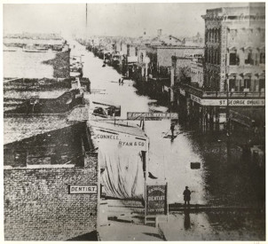
During the flood of 1861-62, the biggest flood on record in California, Sacramento was underwater and the Legislature had to temporarily move to San Francisco. (Photo courtesy of California State Library)
We normally get several smaller atmospheric river storms every year. So we could get some small ones, which last just two or three days. Stronger atmospheric river storms don’t necessarily correspond to El Niño years, however. But we’re predicting bigger ones in the future. If we go back in time in geologic records, we see that a big storm (and “megafloods”) recurred every 100 to 200 years. The only megaflood on record was in 1861-62, which was the biggest flood on record in California. It filled the entire Central Valley, which is 300 miles long and 20 miles wide, with 10 feet of water. It’s been 160 years since that flood, so any given year now, it’s a possibility that another will occur. Everyone knows about the big earthquake that might hit the San Andreas, but few people know about these megafloods.
What would the impact be if another big storm hits?
In 1861, the state had 43 straight days of rain. The USGS created a scenario based on this flood, but with only 23 days of flooding, and still the water filled the Central Valley and 25 percent of houses in the state were damaged and 1.5 million people would need to evacuate. It produced $400 billion in damage. It would be a major disaster.
How can people prepare for this disaster when it happens?
Don’t buy a house in a flood plain. Already, more than 6 million people live in the Central Valley and that’s where all of our future development is slated to take place. It’s just crazy to me that they can even continue to build these developments in places that are so susceptible to flooding.
So can we relax our water conservation efforts?

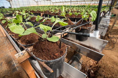
Micro-drip watering systems help to conserve water in agriculture. (Flickr photo by USDA)
No — right now, our water usage is greater than our water supply. We need to change how we’re using water. Not just in conservation, but in water recycling and reusing grey water. We also need to increase efficiency in agriculture by revamping watering systems, and we need to start charging more for water and regulating groundwater. We’re the only state that doesn’t regulate groundwater. Our groundwater is our bank account and we’ve been depleting it.
In 2014, Gov. Jerry Brown signed legislation to strengthen local management and monitoring of groundwater basins — the first time in California history — and in March 2015, he announced a billion-dollar drought relief plan. Although some say it could take up to a decade to implement, is this a step in the right direction?
Groundwater is an important reservoir of water, particularly in drought-prone regions like the American West. It is critical to monitor and regulate this critical water resource, so I am encouraged that the state will be doing this in the near future.
B. Lynn Ingram is a professor of earth and planetary science at UC Berkeley. She is the author of The West Without Water: What Past Floods, Droughts and Other Climatic Clues Tell Us About Tomorrow, co-written with geographer and environmental biologist and visiting scholar Frances Malamud-Roam.