Wildfire management vs. fire suppression benefits forest and watershed
Experiment in Yosemite National Park shows that wildfire management can produce an ecosystem more resilient to fire
October 24, 2016
An unprecedented 40-year experiment in a 40,000-acre valley of Yosemite National Park strongly supports the idea that managing fire, rather than suppressing it, makes wilderness areas more resilient to fire, with the added benefit of increased water availability and resistance to drought.

A severe fire cleared an area of forest in the Illilouette Creek basin in Yosemite National Park, allowing it to become a wetland. Wetlands and meadows provide natural firebreaks that make the area less prone to catastrophic fires. (Scott Stephens photo)
After a three-year, on-the-ground assessment of the park’s Illilouette Creek basin, UC Berkeley researchers concluded that a strategy dating to 1973 of managing wildfires with minimal suppression and almost no preemptive, so-called prescribed burns has created a landscape more resistant to catastrophic fire, with more diverse vegetation and forest structure and increased water storage, mostly in the form of meadows in areas cleared by fires.
“When fire is not suppressed, you get all these benefits: increased stream flow, increased downstream water availability, increased soil moisture, which improves habitat for the plants within the watershed. And it increases the drought resistance of the remaining trees and also increases the fire resilience because you have created these natural firebreaks,” said Gabrielle Boisramé, a graduate student in UC Berkeley’s Department of Civil and Environmental Engineering and first author of the study.
Boisramé and co-author Sally Thompson, a UC Berkeley ecohydrologist and assistant professor of civil and environmental engineering, found that even in the drought years covered by the study, the basin retained more water than similar areas outside the park. That translated into more runoff into the Upper Merced River, which flows through Yosemite Valley, at a time when other rivers in the surrounding areas without a restored fire regime showed the same or decreased flow.
“We know that forests are deep-rooted and that they have a large leaf area, which means they are both thirsty and able to get to water resources,” Thompson said. “So if fire removes 20 percent of that demand from the landscape, that frees up some of the water to do different things, from recharging groundwater resources to supporting different kinds of vegetation, and it could start to move into the surface water supplies as stream flow.”
The study is published in the current issue of the journal Ecosystems.
If the results are confirmed from other studies, including the UC Berkeley team’s new project analyzing the Sugarloaf Creek Basin in Sequoia and Kings Canyon national parks, they could alter the way the federal government as well as water districts deal with fire, benefiting not only the forest environment but potentially also agriculture and cities because of more runoff into streams and reservoirs.
“I think it has the potential to change the conversation about wildfire management,” said co-author Scott Stephens, a fire expert and UC Berkeley professor of environmental science, policy and management who has studied the Illilouette basin since 2002.
This “wildfire management” strategy is counter to the federal government’s 110-year-old Smokey Bear policy, which is followed throughout the West and emphasizes suppressing fires wherever they occur for fear they will get out of control. With persistent drought and a warming climate, the U.S. Forest Service budget is increasingly going to firefighting. On most federal land, only forest thinning and human-initiated prescribed burns are allowed as a way to manage the trees and underbrush.
Stephens noted, however, that these agencies have recognized the folly of total suppression — thanks in part to his own studies throughout the Sierra Nevada over several decades — and current draft wildland management policies for three of the state’s national forests allow active wildfire management in up to 60 percent of the forests.
The value of forest clearings
Wildfire management, as opposed to suppression, comes with major changes in the way the forest looks, Stephens and Thompson said. Unlike the dense stands of pine and fir most people associate with Yosemite and similar mid-elevation Sierra Nevada and Rocky Mountain forests, the Illilouette Creek basin has thinner forests and more clearings with dead trees.

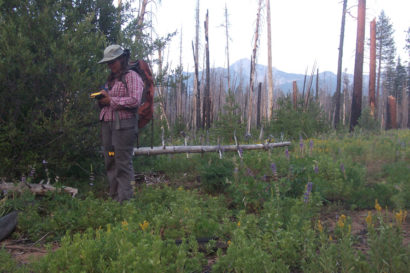
Graduate student Kate Wilkin gathering data in the field in the Illilouette Creek Basin, which bears the scars of many natural fires. Gabrielle Boisramé photo.
“There is much more dramatic structural change in this forest than most people would probably feel comfortable with,” he said. “You are talking about low-density forests and gaps of 4 or 5 acres, up to maybe 100 acres. These are the result of major fires about every decade or so, large enough to cause tree scarring and affecting as much as one-quarter of the basin.”
These fire-caused clearings, however, act as natural fire breaks and make the area resistant to catastrophic fires such as the 2013 Rim Fire in the western part of the park, which burned 250,000 acres and left patches up to 20,000 acres in which not a single conifer tree survived. These areas could take a century to recover, Stephens said.
“In the Illilouette basin we lost about 20 percent of the forest cover, but there was a 200 percent increase in wetland vegetation: meadows starting to reemerge from forests that have probably encroached on historical locations,” Thompson said. “That sets us up to think that this new regime should be leakier as far as water goes — leaky in the way that suits us as a society.”
Even if these wildfire management techniques don’t produce more runoff, Thompson added, “I think it is a fabulous result in terms of forest management if you end up with a healthier forest with some better intact aquatic habitat, even if you don’t see a drop of water further downstream. It is still the right thing to do from an ecological point of view.
“Bottom line, this strategy might be a triple win-win-win for water, forest structure and fire risk,” she said.
The ‘jewel’ of Yosemite National Park
The findings are the culmination of a 14-year study led by Stephens and his UC Berkeley colleagues to learn how monitoring natural, lightning-caused fires with a bias toward letting them burn affects the landscape, the vegetation and the groundwater. Only four areas in the western U.S., including two in California — the Illilouette Creek basin and the Sugarloaf Creek basin — have allowed lightning fires to burn in large areas for decades.

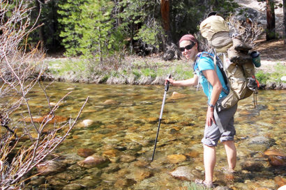
Graduate student Gabrielle Boisramé crossing Illilouette Creek in Yosemite National Park. (Diane Taylor photo)
Most studies of different ways to manage wildland fires have been limited to a few hundred acres, and it’s hard to extrapolate from such limited experiments to an entire forest. Luckily, Yosemite National Park started its experiment in 1973 — spurred by a 1963 report authored by the late UC Berkeley forester Starker Leopold — to let nature take its course in the Illilouette Creek watershed, stepping in only when fires in the basin threatened to get out of control or sent too much smoke into Yosemite Valley two miles to the northwest.
“This is the first study that looks at fire regime restoration on a watershed scale with empirical data,” he said. “Others do smaller areas or modeling, but this is 40,000 acres — a big place — over many years.”
One reason the basin was chosen was that it was surrounded by granite walls, which naturally prevented fires from spreading outside the basin. It had not been burned by the indigenous tribes of the region, which often set fires to increase acorn production, and had no history of prescribed burns. In fact, it saw only natural, lightning-caused fires except for an interval of nearly a century — 1875 to 1972 — when the park suppressed all fires.
While Stephens and his many students documented the changes in fire over the past 400 years, Boisramé and Thompson analyzed aerial photos to document vegetation change. Then, with the help of installed sensors and more than 3,000 soil moisture measurements throughout the basin, the team was able to estimate the amount of water in the landscape today versus in the past. They found similar or marginally drier conditions where forests had been replaced with shrubs, but these were balanced by much wetter conditions in small areas where meadows expanded.
They observed more snow reaching the ground because of the clearings, and more snow remaining during the spring, delaying runoff. And in recent drought years, when surrounding basins saw more trees die, there was almost no tree mortality in the Illilouette basin.
“In order to really understand whether this approach should be part of our management toolkit, I would recommend that we give it a crack in a few other places,” Thompson said. “This appears to be a promising management strategy without significant harm and with several very strongly quantifiable benefits and several very suggestive outcomes.”
Boisramé, who spent the past four summers sampling and camping in the Illilouette Creek basin, emphasized that this is not a strategy that would work everywhere. But in wilderness areas where wildfire management is being considered because of its safety benefits — to reduce underbrush and eliminate fuel for out-of-control and catastrophic fires that risk lives and property — the ecological and hydrological benefits are a big bonus. Areas with similar elevation and climatic conditions to the Illilouette basin, and thus perhaps suitable for managed wildfire, comprise about 18 percent of the Sierra Nevada, though the strategy may work at lower elevations as well.
“The whole ecosystem will be better off if we let the natural fire process back in,” she said.
The research was supported by a grant from the federal Joint Fire Science Program.
RELATED INFORMATION