For more resilient cities, think small(er) and look to vacant lots
Nicholas de Monchaux's data-driven new book, 'Local Code,' explores digitally tailored interventions for vacant public land in SF, LA, NY and Venice, Italy
November 1, 2016

Nicholas de Monchaux suggests in his new book that planners and others looking to make cities more resilient reconsider the potential of small projects, even as small as the vacant lot.
A new book by UC Berkeley architecture professor Nicholas de Monchaux argues that the most valuable resource to boost American cities’ resilience in the face of climate change is the lowly vacant lot.
Local Code – 3,659 Proposals About Data, Design and the Nature of Cities looks a bit like a graphic novel, with the bulk of its 219 pages devoted to large and small blue, gray and white computer-enhanced sketches illustrating the potential transformation of ignored or abandoned public streets, lots, rights-of-way and alleyways in New York City, Los Angeles, San Francisco and Venice, Italy.

For his analysis, author Nicholas de Monchaux used existing surveys of vacant lots, crowdsourcing and collaboration with urban ecologists and UC Berkeley faculty and students.
De Monchaux, a faculty member at Berkeley’s College of Environmental Design, taps into digital mapping tools and data science to devise what he describes as fresh, efficient and fair ways to reinforce cities’ physical, social and ecological resilience to face the growing and multi-faceted hazards of climate change.
Downhill, downstream, down at the heel
“The same spaces generally abandoned and avoided by normal urban mechanisms of occupation, exploitation and use turn out to have several very essential qualities in common: From an ecological perspective, they tend to accumulate in parts of the city — downhill, downstream, down-at-heel — where ecological interventions are most transformative, and best buffer the city against physical threats, from floods to heat waves,” de Monchaux writes.
The maintenance and improvement of urban centers is increasingly critical, with 3 billion more people projected to live in cities by the year 2050 — making all design urban design, he argues.
To bolster de Monchaux’s claims, Local Code includes colored maps plotting the incidence of cancer and respiratory ailments, urban heat islands, carbon output, crime and poverty rates, and ways to remake vacant lots into practical and healthy extensions of systems and other public works initiatives already operating in each city studied.
Moving toward equity
De Monchaux acknowledges that since the epic flood and wind damage caused by Hurricane Sandy in 2012, New York has been working to better safeguard the city from the next environmental disaster.
“Yet most of these proposals recapitulate the historic tendency to invest vast resources in already well-off neighborhoods, or to produce readily comprehensible, singular artifacts such as levees (the ribbon cuttings for which provide evidence of political action),” he writes.
In proposing that infrastructure dollars could be distributed more effectively to underserved communities, de Monchaux asserts that effort is also “about which neighborhoods get left out, and which neighborhoods get included.”

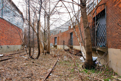
Lots such as this one in Queens were among the 1,500 examined by de Monchaux. (Photo courtesy of Creative Commons.)
In collaboration with the urban ecology lab of Timon McPhearson at the New School’s Parsons School of Design, de Monchaux developed what he calls an “urban acupuncture” plan that complements storm water and heat island mediation projects with the creation of shared public spaces, job training and local health and welfare to bolster urban areas’ economic and social health. The book examines over 1,500 lots in New York specifically sampled and studied by McPhearson’s lab for their significant potential ecological contribution.
A single site in Queens, for example, could be planted with trees, urban gardens and flood-friendly bioswales and reduce local storm water flooding by half, as well as saving 990 kilowatt hours in local energy usage through moderating the urban heat island.
The 1,500 proposed interventions in New York would together reduce energy costs by 11.5 gigawatt hours and reduce flooding in neighborhoods there by up to 47 percent. (One gigawatt equals 1,000 megawatts, or enough to supply a medium-size city.)
Beneath the billboards
For Southern California, Local Code offers images and maps of unused lots under billboards along the Los Angeles River Basin.

There’s a lot of potential for all that empty space under and around freeway billboards, says de Monchaux.
With no official map of such vacant parcels, information collected from community residents was combined with an online crowdsourcing effort to identify more than 700 candidate sites, in collaboration with the Pasadena-based nonprofit Amigos de los Rios.
The sites are reimagined with water-focused improvements such as drought-resistant planting, storm water retention and filtering, and planting a shade canopy or produce garden to improve air and water quality and offer public amenities from Avenue 22 in Chavez Ravine to Ocean Front Walk on Santa Monica Beach.
A single site near Century City in Los Angeles, for example, could capture and filter many thousands of gallons of water in storm surges, capture 125 pounds of atmospheric carbon per year and reduce the urban heat island sufficiently to save 980 kilowatt hours of electricity, reducing energy costs and increasing comfort.
All the proposed L.A. interventions together would absorb a million gallons of storm-surge, and save 13.1 gigawatt hours of energy by helping to alleviate the urban heat island.
Not so Golden Gate
A similar examination of unmaintained rights-of-way owned by the city of San Francisco — and therefore “institutionally invisible” — are recreated by de Monchaux with an eye toward better water flow, more exposure to sunlight and improved air circulation or wind movement.
The effort, which stemmed from a single spreadsheet in the city’s public works department, resulted in more than 1,500 redesigns that he contends could be realized by redirecting public funds already devoted to storm water management, producing a far more resilient flood management system than traditional culverts and sewers.

For his Local Code resesarch, de Monchaux wrote the first software that robustly connects urban mapping databases such as Google Earth to contemporary, data-driven design software.
One single site near Bayshore Boulevard, for example, is covered with degraded asphalt and compacted soil. Equipped with landscapes for storm water retention, heat island mediation and the absorption of particulate pollution, de Monchaux estimates this parcel could save the city more than $3.4 million over 30 years, at about half the cost of underground sewer work. At the same time it would create a healthier, better-connected community.
In the process, the site would capture hundreds of pounds of carbon annually, and could produce nearly 180 bushels of edible produce.
All the proposed San Francisco interventions together would reduce the load on city storm sewers by 67 percent, and generate up to 12.1 gigawatt hours in energy savings, de Monchaux estimates.
Crowdsourcing and new software
In his analysis, de Monchaux relied on existing surveys of vacant lots, crowdsourcing and collaboration with urban ecologists in New York and Venice, Italy, and with fellow UC Berkeley faculty and students.
“Before the availability of digital mapping tools, finding and imagining futures for such sites was an exercise in herculean bookkeeping and singular imagination,” writes de Monchaux, who also is director of UC Berkeley’s Center for New Media. But while understanding and filtering the collected information is becoming less daunting, he says the work is still tricky.
There’s a reason it took him six years since publication of his last book to publish again, says de Monchaux.
To analyze and design for many thousands of lots individually, de Monchaux wrote the first software that robustly connects urban mapping databases such as Google Earth to contemporary, data-driven design software. De Monchaux says incorporating the book’s drawings involved laying out each image according to its geographic position, and sizing each according to the potential ecological impact.
Interspersed with de Monchaux’s case studies are essays about lessons he learned from urban observer Jane Jacobs, ex-architect as well as artist Gordon Matta-Clark and digital mapping pioneer Howard Fisher about architecture, mapping systems originally developed to shoot down Soviet bombers, how to “reframe” urban renewal, and the importance of adaptation in urban environments.
A closer look at the book and some of its images is available online.