Sinking land will exacerbate flooding from sea level rise in Bay Area
New satellite measurements show that areas around the Bay at risk of inundation could be twice earlier estimates
March 7, 2018
Rising sea levels are predicted to submerge many coastal areas around San Francisco Bay by 2100, but a new study warns that sinking land — primarily the compaction of landfill in places such as Treasure Island and Foster City — will make flooding even worse.

Yellow areas are parts of the San Francisco Bay shoreline at risk of flooding by 2100 because of sea level rise (SLR) alone, while red indicates those areas at risk because of both sea level rise and local land subsidence (LLS), based on a new study by UC Berkeley and Arizona State geologists. (Images by ASU/Manoochehr Shirzaei)
Using precise measurements of subsidence around the Bay Area between 2007 and 2011 from state-of-the-art satellite-based synthetic aperture radar (InSAR), scientists from the University of California, Berkeley, and Arizona State University mapped out the waterfront areas that will be impacted by various estimates of sea level rise by the end of the century.
They found that, depending on how fast seas rise, the area at risk of inundation could be twice what had been estimated from sea level rise only.
Previous studies, which did not take subsidence into account, estimated that between 20 and 160 square miles (51 to 413 square kilometers) of San Francisco Bay shoreline face a risk of flooding by the year 2100, depending on how quickly sea levels rise.
Adding the effects of sinking ground along the shoreline, the scientists found that the area threatened by rising seawater rose to between 48 and 166 square miles (125 to 429 square kilometers).
“We are only looking at a scenario where we raise the bathtub water a little bit higher and look where the water level would stand,” said senior author Roland Bürgmann, a UC Berkeley professor of earth and planetary science. “But what if we have a 100-year storm, or king tides or other scenarios of peak water-level change? We are providing an average; the actual area that would be flooded by peak rainfall and runoff and storm surges is much larger.”
The data will help state and local agencies plan for the future and provide improved hazard maps for cities and emergency response agencies.
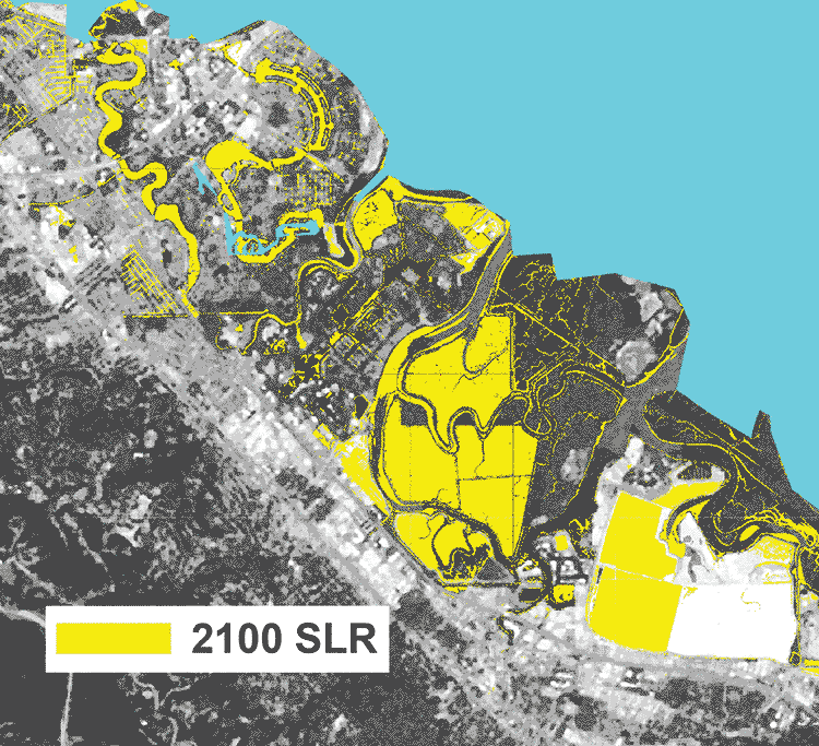
Foster City, many areas of which could be flooded in 2100 because of rising sea levels (SLR, yellow), will be even more at risk because of local land subsidence (SLR+LLS, red).
“Accurately measuring vertical land motion is an essential component for developing robust projections of flooding exposure for coastal communities worldwide,” said Patrick Barnard, a research geologist with the U.S. Geological Survey in Menlo Park. “This work is an important step forward in providing coastal managers with increasingly more detailed information on the impacts of climate change, and therefore directly supports informed decision-making that can mitigate future impacts.”
The low-end estimates of flooding reflect conservative predictions of sea level rise by 2100: about one and a half feet. Those are now being questioned, however, since ice sheets in Greenland and West Antarctica are melting faster than many scientists expected. Today, some extreme estimates are as high as five and a half feet.
That said, the subsidence – which the geologists found to be as high as 10 millimeters per year in some areas – makes less of a difference in extreme cases, Bürgmann noted. Most of the Bay Area is subsiding at less than 2 millimeters per year.
“The ground goes down, sea level comes up and flood waters go much farther inland than either change would produce by itself,” said first author Manoochehr Shirzaei, a former UC Berkeley postdoctoral fellow who is now an assistant professor in ASU’s School of Earth and Space Exploration and a member of NASA’s Sea Level Change planning team.
Shirzaei and Bürgmann will publish their findings March 7 in the online journal Science Advances.
Combining InSAR and GPS
InSAR, which stands for interferometric synthetic aperture radar, has literally changed our view of Earth’s landscape with its ability to measure elevations to within one millimeter, or four-hundredths of an inch, from Earth orbit. While it has been used to map landscapes worldwide – Bürgmann has used InSAR data to map landslides in Berkeley and land subsidence in Santa Clara County – this may be the first time someone has combined such data with future sea level estimates, he said. The team used continuous GPS monitoring of the Bay Area to link the InSAR data to sea level estimates.
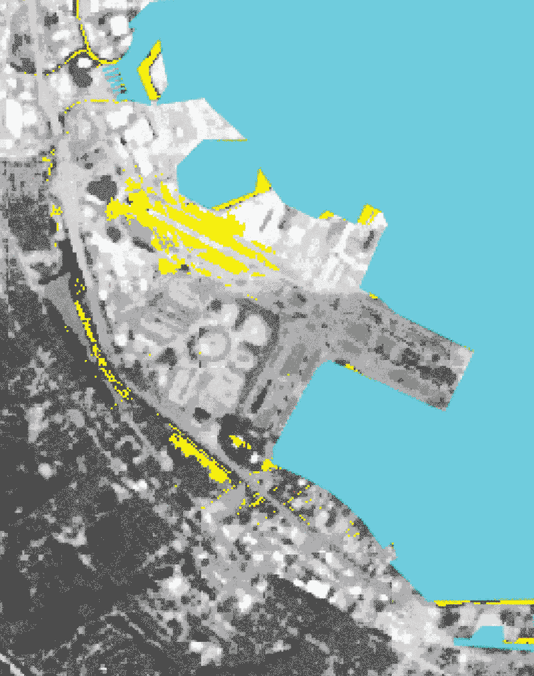
San Francisco International Airport’s runways will be flooded by 2100 because of sea level rise (yellow) and subsidence of landfill used to construct the airport (red).
“Flooding from sea level rise is clearly an issue in many coastal urban areas,” Bürgmann said. “This kind of analysis is probably going to be relevant around the world, and could be expanded to a much, much larger scale.”
In the Bay Area, one threatened area is Treasure Island, which is located in the Bay midway between San Francisco and Oakland and was created by landfill for the 1939 Golden Gate International Exposition. It is sinking at a rate of one-half to three-quarters of an inch (12 to 20 millimeters) per year.
Projections for San Francisco International Airport show that when land subsidence is combined with projected rising sea levels, water will cover approximately half the airport’s runways and taxiways by the year 2100. Parts of Foster City were built in the 1960s on engineered landfill that is now subsiding, presenting a risk of flooding by 2100.
Not all endangered areas are landfill, however. Areas where streams and rivers have deposited mud as they flow into the Bay are also subsiding, partly because of compaction and partly because they are drying out. Other areas are subsiding because of groundwater pumping, which depletes the aquifer and allows the land to sink. In the early 20th century, the Santa Clara Valley at the south end of San Francisco Bay subsided as much as nine feet (three meters) due to groundwater depletion, though that has stabilized with restrictions on pumping.
Shirzaei noted that flooding is not the only problem with rising seas and sinking land. When formerly dry land becomes flooded, it causes saltwater contamination of surface and underground water and accelerates coastal erosion and wetland losses.
The work was supported by the National Science Foundation, National Aeronautics and Space Administration and Point Reyes Bird Observatory Conservation Science.
RELATED INFORMATION